Wednesday, June 12, 2013

Seven Bears, a Signpost Forest, and our first Totem Poles


Continuing to Play Catch Up:

Sunday:


Sunday proved to be a seven-bear day. Waiting for a flagwoman to pass us down the highway through a construction site, I listened to the “neighbors” in the jam of traffic who were standing beside their vehicles talking about all the animals they had seen.  Several people said they had already seen five bears.  I countered with seven!  One woman said we had unfair advantage because we sat so high up.  Tough!

The first bear (at left) had a mouthful of dandelion flowers.  I got stopped and stuck the camera out the window just as he turned and hid his face.  I saw a lot of bear butts today.  They all seemed camera shy. The high point, though, was a black bear cub trying to catch a butterfly.  Like a kitten chasing a string.  No photo there either.


We rolled into Watson Lake in time to buy more $5 gas and visit the famous Signpost Forest.  Some homesick GI once put up a post with a sign giving the name of his hometown.  37,000 more people followed his lead.  Ok, 37,002 people.  Marsha and I had brought along a sign from neighbor Larry Janzen’s “3 ½ Happy Barbers” shop in Green Valley.  Larry has photos of his signs taken all over the world in places where his customers have traveled.  He will now have one more for his collection


We found we were not the first folks from Show Low to make the trip.  There was a large sign here pointing the way to Show Low City Hall, about 2500 miles south (Look for a blue sign at the lower right).


The town of Watson Lake came about when the Army Air Corps built a major airfield on the lake during WWII.  It was one of a long string of fields built from Great Falls, Montana, to Nome, Alaska to allow pilots to deliver Lend-Lease aircraft to the Russians.  The original Alaskan highway was built to link all these airfields together. At the old Watson Lake flight ops building Marsha and I saw photos of hundreds of B-25 Mitchell bombers and P-39 Airacobra fighters lined up at the Watson Lake airfield ramp in the 40s.  All these American planes were wearing the red star insignia of the Russian Air Force.  Our greatest nightmare of the fifties had actually come true back in the 40s; Russian planes and pilots routinely “invaded” Alaska and Canada. Then flew home in brand new aircraft.


It stays light here until well after midnight, so about 8:30 pm (it looked to be about 4:30)  Marsha dragged me to the Northern Lights Planetarium to see a program about, you guessed it, the Northern Lights.  She slept through most of it, but I learned that there were auroras above us right then. We just couldn't see them because we were locked inside a planetarium.  And also, we couldn't see them until after sunset anyway.  Which will come sometime in October.

We spent the daylight night in a Yukon government campground on the opposite side of Watson Lake (the actual lake, with water) from the Watson Lake airfield.  And two miles west of the town of Watson Lake. They had free firewood and free mosquitoes.  We stayed inside. But it was gorgeous.


Monday:


We carried on west from Watson Lake, stopping at Rancheria Falls on the Rancheria River.  From the name, it sounds like it should be in LA (lower Arizona).  The facilities in both British Columbia and the Yukon are first rate, by the way.  Super roads, great campgrounds, and here they had thoughtfully built a boardwalk out 500 meters through the forest to the falls.


A friend in Wyoming once told me his state had only two seasons:  Winter and Roadwork.  True here also, apparently.  We found a crew spreading a slick of oil on the road then covering it immediately with a layer of gravel.  When we got to the part they had finished, it appeared they used twice as much gravel as the oil could glue down.  I remarked to Marsha that it also appeared that they were installing brand new washboard on what had before been a perfect road. But soon, the smooth road reappeared ahead of us.


We also stopped at the Tlingit Heritage Center in the village of Teslin, where they had a small museum with a first rate building and art exhibits.  By the way, Tlingit is pronounced “Klink-It.” They were and are the totem pole builders of western Canada.


All together, we drove 300 miles from Watson Lake to Whitehorse, Yukon, on Monday. To put Whitehorse into perspective, I should tell you that it is about 100 miles north and east of Skagway, Alaska. And much further north from the capital of Alaska, which is Juneau. We got into Whitehorse late and found all the campground filled. So we joined 100 of our closest friends in the Walmart parking lot for the night.  We found a man who looked a lot like our Green Valley neighbor John Luce, getting a haircut next to his motorhome in the Walmart parking lot.


Tomorrow will be another day.  Actually, as I write that I realized it already is tomorrow.  Midnight slipped right past me here in the land of the midnight sun. It tends to do that.


Next installment: The first Alaska Gold Rush (which actually took place here in Canada’s Yukon).


All photographs copyright 2013 John B. Taylor (I add this because apparently they wind up stashed on Google)


Tuesday, June 11, 2013

Rocky Mountain High: Thru Canada's Northern Rockies


When you last heard from us we were in Fort Nelson, B.C. ready to leap off on our next leg of the Alaskan Highway.  We had no idea how different the next 600 miles would be from our first 2500. Picture driving into Yellowstone and the Tetons and finding they are now the size of several states and the tourists stayed home.  That what the Great Northern sector of British Columbia and the lower Yukon seem like. Spectacular, pristine and mostly devoid of people.

I’m behind, so now that we finally have wifi (an hour a day) I'm going to post my account of the leg from Fort Nelson to Whitehorse a couple of days at a time.  Here are Friday and Saturday:

Friday:


As I write this Friday night, we are sitting at a rest stop at Mile 461 of the Alcan Highway next to a big sign that says “Wildlife Viewing Area.” It has an arrow pointing up towards the mountains.  That arrow is misdirected.  Not twenty feet in front of our motor home are a pair of big horn sheep, grazing on bare dirt.  Four more sheep are doing the same right behind us. Technically they are Stone’s Sheep, a brown
 version of the white Dall sheep found further north.  But these rams do have big horns.  They nibble the ground to get the remains of the salt the Province put on the turnout last winter.  Then they spit out the gravel.


Just across the road is a beautiful blue lake.  The color is a deep blue-green even though the sun has been hiding most of the day and there is no blue sky for it to mirror.  It doesn’t need it. 
The guidebook says the color comes from copper oxide that has leached into the water.  It is Muncho Lake, named for an Indian word meaning “big lake.”  So those of us from the southwest can think of Muncho as Mucho Lake.


This was one heck of a day.  We only made it about 135 miles from Fort Nelson, and drove those miles at about 40 mph because the road twisted and turned, then went uphill and downhill.  But the real reason we went slowly was that the scenery is so spectacular.  This looks like a bigger version of our Glacier National Park.  We are in the Canadian Northern Rockies, with snow capped mountains on all sides; rivers at the bottom of deep canyons filled with dark green conifer forests.  Yellow flowers everywhere. Wow.  And animals wherever you look.  We saw two black bears, dozens of sheep, two mule deer, quite a few small caribou (we first thought they were young moose), at least one elk, plus a motorcyclist and a flock of seagulls here by the lake.


We pulled over to check out the Wildlife Viewing Area and found a couple from New Hampshire/Yuma (summer/winter) sitting here in their trailer.  They said they had been hiking the trail that leads out of the pullout and had seen lots of bears and other animals. They decided they were going to stay the night.  We decided to stay here too, so we can drive the length of the lake in sunshine tomorrow (we hope). Marsha says the lake goes another 50 miles from this point, or maybe seven, she isn’t sure.  We think we are about 50 miles from the Muncho Lake campgrounds.  So maybe the campgrounds are named for a lake they aren’t near.  Inquiring minds want to know. Stay tuned.


Tomorrow will be exciting. 

Saturday:


Well, we got all packed up, pulled the slides in and drove less than a mile before arriving at the first Mucho Lake campground.  But we are hardy travelers, so we journeyed on another full mile to the MacDonald Provincial Campground right smack on the lake. We had heard the Provincial campgrounds are small, and built for tents.  But the dozen or so spaces here would all accommodate the motor home.  So we picked a site and settled in for the night.  The only thing between the lake and us is one tree. It’s incredibly beautiful.


This was about 10:00 am, so we had a ways to go before dark.  More than 12 hours, actually, since sunset occurs about 10:30 pm in these latitudes. So we decided to go to the Northern Rockies Lodge for lunch.

I had to start by checking out the really beautiful floatplane at their dock, hovering majestically on the surface of the blue lake.  It was a really ancient, but brand new looking DeHaviland Otter that someone had totally rebuilt with a Pratt & Whiney jet-prop engine.  


Its young pilot told me it hauled nine passengers and climbed like a scalded angel. They use it to take fishermen and women into distant lakes where they offer one log cabin per lake, huge fish and lots of privacy. They had a wooden map showing the cabin locations in the lodge.

The menu in the lobby of the lodge showed a luncheon hamburger for $12, but we figured it would be worth it to use their Wi-Fi.  We ordered the Bush Pilot Burger, which the cook apparently thought meant post-crash because it arrived heavily charred, on a burned bun, and with overdone fries. The actual price of the burger turned out to be $20 (each). I’d apparently seen the kid’s menu earlier.  Naturally, their Wi-Fi didn’t work. We passed on their $8-a-gallon gas, which had to be hauled up by truck from Edmonton.

After that treat, we got in the Jeep and drove down the highway 50 miles to preview tomorrow’s drive and poke around more than we could do with the motor home.  More spectacular scenery!  We went down the Trout River to the Liard River and found the Liard River Hot Springs, located at another nice Province-run campground.  You walk out to the hot springs on a boardwalk and see a bunch of old folks getting themselves into hot water.  It was a very nice facility with a terraced deck system that takes you right into the hot springs.  We hadn’t come prepared to swim.


Back at the campground we spent the afternoon sitting in the front seats reading and looking out at the lake.  When it got chilly, the mosquitoes vanished and we went for a walk.  What an incredible place to visit.

Tomorrow on into the Yukon Territory and the town of Watson Lake, for the laying of the 3 ½ Happy Barbers sign.


Thursday, June 6, 2013

Along the Alaska Canada Highway

We drove west out of Edmonton on Tuesday morning, headed northwest. We got as far as Grande Prairie that night.  The road to Grande Prairie was across, well, a grand prairie.  We departed the next morning headed towards Fort Nelson, British Columbia.  It rained all the way from Grande Prairie to Dawson Creek., the official start of the Alaskan Highway.


We stopped in Dawson Creek, 2000 miles from Show Low, and wandered around long enough to see the visitor center and the Alaska Highway House for a very nice exhibit on the building of the Alcan during WWII. It seems a group of Japanese attacked Hawaii and this somehow made Alaska strategically important.  Important enough that it deserved a road.  So in March of 1942 one group of soldiers started north from Dawson Creek while at the same time a second unit started building south from Fairbanks, AK.  More than 11,000 troops penetrated 1500 miles of mountains and muskeg in freezing temperatures.  I don't know what a "muskeg" is, but they got over it and both units met only 8 months later, completing the road.  The road was bulldozed through the wilderness, using 90 degree turns and 25% grades and logs for paving.  Since then, someone paved it with regular road material. And straightened out a lot of it. Thank goodness!

Dawson Creek also had some interesting murals painted on the back walls and fences of the town. Marsha took this shot  of one of them.


Our neighbors in Show Low, Ron and Bonnie, once tried a motor home trip to Alaska but got no further than Dawson Creek, where it rained on them steady for two weeks.  We found the rain stopped a mile or two north of D.C., but that was then and this was now. Heading north we found a Y where a wide paved road went to the left while a narrow track headed to the right.  Naturally, the Alcan was on the right. The right was also windy.  Really windy.

We got only as far as Fort St. John and its Walmart parking lot, where the Canadian flag appeared to be starched straight out.  Too much work at the wheel, so we quit for the day.
We did a walking trail on the edge of town and had dinner at a Saigon Noodle place at the mall (which closed nightly at 6 pm). We briefly considered going to see Star Wars: Into the Darkness, but the 3D glasses and $13 price (senior rate) made us re-think it.  


Gas in Fort St. John was $136.9 a liter, or  $5.18 a US gallon.  We tried to top off at the Flying J but there was no one home and the pump didn't want to take my credit card, so we headed north.  Big mistake.


We got to Fort Nelson in the middle of the afternoon and pulled into the Triple G Campground.  We managed to get all this way from Show Low without buying space in a campground, since we had visits with Cousins JoLene and Steve, then neighbours Rick and Geri. Places with regular showers.  But Marsha figures we are bound for Provincal campgrounds for the next few days so she needed a shower tonight.  Cost: $40.  But it did include water.

Gas here is $6 a gallon (US) so we should have topped off in Fort St. John.  I'd never before actually seen $5 gas in my whole life, and today we sailed way past that mark.  We had the whole afternoon to see Fort Nelson, which took between five and ten minutes. But, ok, we needed some time at home to use our computers.  By the way, the weather is still really nice.  67 degrees and dry. The forests are very thick, with a mix of Fir and Aspen.  I never knew Aspens would grow at 2000 ft elevation but they do.  This area is an "energy"  boom town.  We assume that means oil. There are drilling companies everywhere.  And lots of trucks.

Tomorrow we visit the bank for a mortgage, then buy 80 gallons of gas and move on towards the west a bit.  Muncho Lake maybe.  Stay tuned.

Sunday, June 2, 2013

God Save The King


In the movie "Field of Dreams" there is a scene where a baseball player calls out to Kevin Costner's character, asking, "Is this heaven?"  

Kevin replies, "It's Iowa."  

Well, Edmonton, Alberta looks a lot like Madison County, Iowa. And parts of Tennessee.  But without their humidity and oppressive summer temperatures.  Edmonton stays around 68 degrees.  Ok, they do temps here in metric, so it would be 20 degrees. Sure does seem like 68F.

We got here at the end of the week after braving strong winds, rain and traffic all the way up from the border. Edmonton is about 400 miles north of the U.S. border, but the speed limit is 110 Kph (that's in kilometers) so you get here a lot faster.   No, that doesn't make any sense. I get that.  But it just seems faster in kilometers.


We are visiting our winter neighbours, Rick and Geri Beaumont (left).  During the winter they live across the street from us in Green Valley, but return to their native Edmonton for the cool summers.  Most of their neighbors here are retired also, and many of them winter in one part of Arizona or another. They all live on the north side of the city, in a rapidly growing residential area.


On Friday Rick and Geri took us on a tour of this amazing capital city of over a million residents.  It has rolling hills, a river and championship traffic.  And an interesting downtown area. The Art Gallery of Alberta is shown at right. 


The North Saskatchewan River runs through it.


Ukraine West

In the early part of the 20th century, immigrants arrived here from the Ukraine to take advantage of the free land available in Canada.  Rick and Geri took us out to the Ukrainian Cultural Heritage Village just outside Edmonton.  It is something like our Williamsburg in Virginia, where you get to experience what it was like to live in colonial times.  The time period here is later, of course.  Europeans and others continued to arrive here long after the  government lands were gone in the U.S.  At the village we found Ukrainian homes and businesses staffed by the descendants of the hardy immigrants from a hundred years ago.


The staff members stay character, dealing with visitors as if we had just parachuted into Ukrainian Canada in the early 20th Century. It was really fun.


We visited the train station and grain storage elevator.  And got put in jail by the constable and his wife. The jail was in her front parlor.


The immigrants were not ready for the cold winters they found here. While they were building their permanent homes they survived living in structures of poles covered by layers of sod and reeds.  

This nice lady (left) didn't speak much English, but let us know that she was taking care of the sod home and garden of the Burdei family.  Mrs. Burdei, it seemed, was working in the fields somewhere else and her husband had gone off to work in a coal mine. She had no TV, microwave or dishwasher.  Life must have been tough. 

I noticed the garden beside the house had sprouted, and asked Rick if the sprouts were onions.  "Grain," he said.  "You can't make bread with onions."  No, I said, but you can make good Chili...


The highlight for us was our visit to the village schoolhouse. The young teacher was a tough taskmaster. He checked our hands and fingernails for cleanliness before starting our lessons.  Then he had us get our slates out and write down the plural form of tough words like "goose." And graded our penmanship.

Then it got really tough.  In our history lesson he demanded that we write down the names of the original four Canadian provinces.  I was told my effort was lacking.  Apparently, Ottawa is a city not a province, and the Hudson Bay Company was never a government entity.  But I got praised for being able to correctly identify wall portraits of the British King George and Queen Mary. "The last group could only come up with "King" or "George," but never did put it all together," he told us in his heavy Ukranian accent.  I beamed.

On the other hand, I was not able to come up with the dates when the first three major railroads were completed in Canada.  I am apparently going to be held back a grade.  Thank goodness we were supposed to be there in 1927, so I didn't have to name the current prime minister. Or any more provinces.


The best news was that we were able to stand and loudly sing "God Save the King," (left) which sounded a lot like "My Country Tis of Thee." 

The German family seemed puzzled.  They got up and left. They were being held back a grade also.


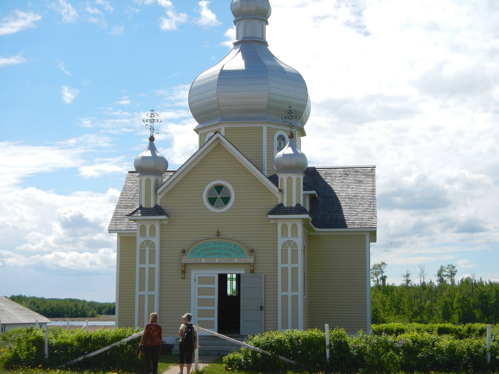
This is a very complete community of businesses and farms.  They even have several Ukrainian Greek Orthodox churches.  In all, there are 60 different buildings in this village, with a dozen more under construction.


Afterwards, we went outside to the food service area and enjoyed Kubasa sausage and Perogies, which are potato dumplings stuffed with onion and topped with sour cream and mosquitoes.


Please note that we are planning to depart here on Tuesday morning and travel northwest toward the start of the Alaskan Highway. We won't have wifi services too often along this road, so this blog may get even more irregular.  While we move through British Columbia and Yukon Territory during the next two or three weeks, our cell phones won't work, and we will only get emails when we happen upon some kind of wifi.  So for the immediate future, please don't send us everything you email out.  We will let you know when we get to Alaska and get back online.  

Onward and Upward!

John and Marsha


Saturday, June 1, 2013

Run for the Border

We're on our way from Arizona to the Yukon and Alaska:

We made it to Moab on day one, only to find the town packed with people and the campgrounds packed as well.  So we kept going into the darkness and ended up in Green River, Utah parked at a truck stop next to a melon patch.  Green River used to be dusty and dry but now river water is available and it is the biggest farm area in the state.  We had eaten in Moab (Zax Pizza) so we just hit the hay.  There were two other trucks in the overflow parking lot when we went to bed.  I got up to close a window in the middle of the night and found we had about 100 neighbors.  They were all gone by the time we got up.


We wandered up the highway into Utah, over Soldier Summit and down into Spanish Fork where we hit I-15.  This was the start of the three day Memorial Day weekend, and my parents are buried in the city cemetery at Payson, Utah.  That's only a few miles from Spanish Fork. Every year my cousins Jolene Coons, Kathy Moore and Linda Stanton have put flowers on their graves, while decorating the graves of their own parents and our grandparents.  This year we were perfectly positioned to join in.  So we did.


On Monday we moved on, going up to Kaysville, Utah where we had an appointment at Blaine Jensen (Camping World) RV to put a new awning on one of our slide outs.  We camped in their driveway overnight, and were first in line the next morning.  We dropped it off and went off to have breakfast.  Our plan had been to head north to Brigham City to overnight at Walmart.  But Jensen's ace service guy Ray Tanner got us done by noon, so we blasted right past Brigham and headed into Idaho.

After driving an hour in a rainstorm, I noticed something odd in my right hand mirror. We'd driven off with the bedroom slide in the out position.  Sigh.  Getting old is no fun. Good thing it was on the  curb side of the bus.

We we continued north through Pocatello and Idaho Falls and made it all the way to Dillon, Montana that night.  Safeways was very accommodating and let us park overnight in an RV parking space they thoughtfully provide in their lot.  In the morning we went to gas up at their service station, only to find that a cattle truck had parked sideways across all the gas lanes. It stayed there while the driver drank coffee and yaked with the girl in the booth. He blocked all the pumps at Safeways for 30 minutes!  One unfrustrated motorist smiled and said, "Welcome to Dillon. People here operate on their own schedule."


We drove through Butte, Montana (above) and then up into the high passes between Butte and Helena.  After Helena we followed a beautiful trout stream that turned out to be the Missouri River.  The same river that Lewis and Clark followed on their way down to Dillon.

We had a snack off the interstate (right) then zipped through Great Falls. We were planning to stay in Shelby at a truck stop overnight.  But it turned out to be a truck stop only the size of a normal gas station, and it was loaded with fifty big trucks and no parking.  So about 5 pm we gassed up and went north.  Gas in Shelby was $3.77 per gallon.

We hit the border an hour later and found the crossing at Coutts, Alberta pretty much deserted.  We were prepared for a long and detailed search, and I had carefully computed how much ammo, liquor and soda crackers (just kidding) we could legally carry across into Canada.  The nice lady in the booth asked if we had firearms; we did.  Since pistols and revolvers are not allowed, I had brought a shotgun and a new Marlin 1895 Guide Gun in 45-70 caliber.  An elephant gun suitable for bear, in case we run into trouble in the wilds of Alaska.  I handed her our passports and the firearms forms the Mounties had posted on their website.

She told me to go inside the building and pay the required fee.  I did that then went back outside, expecting to find Marsha up to her eyeballs in a full-blown inspection.  But Marsha was just sitting there in the bus.  We were all done!  Off we went, down a deserted four lane highway into Canada. Nobody had checked to insure we had the trigger locks in place, and had put a lock on the bed so it would qualify as a "locked" compartment.  They didn't even ask about ammo to make sure we had no more than 200 rounds.

It was all too easy!

(Next blog--Rain and more rain on the way to Edmonton; then a visit to the Ukraine in Alberta)