All photos and text copyright 2015 by John B. Taylor
We may have given you this address to find the blog we published during our 2013 four-month trip through Canada and Alaska and back. It is here, but in order to maintain the site online I've had to post additional blogs at least once a year. If I don't, it will disappear. To find the Alaska blog please look at the upper right corner here, and select 2013. Then, from the pulldown menus you can pick from among the blogs published in June, July, August and September. When you open a given month, it will show you the editions available by title.


Bodie Historical State Park
On the way to Tahoe we stopped at Bodie, probably the best-preserved ghost town in America. It is located near Bridgeport, Calif., just across the state line with Nevada. This mining town once had thousands of people and hundreds of buildings, and many of these structures remain today
Lake Tahoe
This is Emerald Bay on the western shore of the lake. Marsha and I last visited this gem in 1968, the day we picked up our then-new Pontiac GTO convertible. It was deserted back then, but on this visit we found the whole area packed solid with people. Parking was almost impossible. But the beauty remains.

On Tahoe's eastern shore there were fewer tourists. These folks were enjoying a kayak lesson just south of Incline Village. The water level was low (these rocks are normally under water) but Tahoe was not impacted by California's drought nearly as much as the remainder of the state

John and Phyllis showed us some special places. I went to high school with John, half a century ago.
The Mother Lode Country


Yosemite Valley

We decided to visit Yosemite on a weekday, thinking weekends would be more crowded. Guess what? There was not a square inch of the valley not occupied that day. I asked a park ranger how they could possibly deal with all the people there, and he said, "I refuse to work on weekends." I had to wait twenty minutes to take this photo of the Merced River without people in it. But again, the beauty remains. If you can get to it.
Next Stop: Jackson Hole and the Tetons
After three weeks back in Show Low waiting for the heat to ease, we took the motorhome and headed north accompanied this time by neighbors Chris and Paige in their motorhome. First stop on this six week jaunt was Jackson Hole and Grand Tetons National Park.

Here are Chris, Paige and Marsha standing on the bridge over the creek that runs from String Lake down into Jenny Lake.

There are two Moulton Barns on Mormon Row, an old farm settlement now in the park near Antelope Flats. These are the most photographed barns in America, and here you can see why. This was taken at sunset
Approaching Mormon row from the south we found ourselves trapped by
a bison herd that was slowing crossing the road. It took them 20 minutes to cross, and during that time they flowed all around our car.

Glacier National Park
We drove through Yellowstone up to Butte, Montana, then along Flathead Lake to Bigfork, Montana. Bigfork is a neat little town on the eastern shore of the lake. We were hosted by Paige's cousin Ted, and wife Evonne there. Bigfork served as our base to explore Glacier and the area around Kalispell.

This scene was at the top of Going-to-the-Sun Highway. Despite the unusual heat all summer, there was still snow alongside the road. But, like Yosemite, Glacier was completely packed with people, even a week after Labor Day. The last time we were here, maybe ten years ago, it was a week earlier in the year but everything was closed up and we had the place to ourselves. Not this time.

This is the lobby of the elegant old Glacier Park Lodge at the railroad station in East Glacier. It must have taken a lot of thought to build it with these huge logs while leaving the bark on. We were amazed the bark stayed put nearly 100 years.
Coeur d' Alene and Spokane

We headed west from Flathead Lake and drove through the mountains of the Idaho panhandle. Really beautiful country.
I was really impressed by the fly fishing rivers there.
We ended up at Fairchild AFB, about 10 miles west of Spokane. We stayed there three days to give us time to explore Coeur d' Alene, Spokane and Grand Coulee Dam.

We went into Coeur d' Alene and had lunch at a local pub. The area has lots of lakes and we found downtown Coeur d' Alene an interesting mix of shops and restaurants. The flowers were a nice touch.
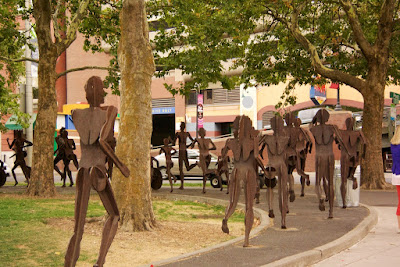
Spokane is home to Gonzaga University. And a river runs through it. There is a park along the riverfront that features these interesting metal figures. I decided it must be some kind of Ironman competition. No winner yet. This race may take a while.
 My grandfather used to tell me stories about working on Grand Coulee Dam, now an hour or so out of Spokane. This dam is a mile across, which made it quite a feat of engineering. He was an engineer. They have a free visitor center and free tours of the dam. We learned that while electrical production is important, the real reason for the dam is to pump water from the impounded Columbia River uphill into a coulee just to the south. This in turn irrigates the inland desert of Washington.


Portland, Colton and Oregon City
We headed down the Columbia River Gorge into Portland, then went south to the farm community of Colton where our friend Terry had room for both motorhomes on his property. We stayed there a week while we explored the area.


We drove up the mountain to Timberline Lodge at the 6000-ft level, then had lunch at the village of Government Camp below. Then, heading north, we came to the Columbia River Gorge, which was home to lots and lots of waterfalls.

This is Multnomah Falls, one of the most dramatic. The old road bridge is now just for walking, but once it was the main road down along the Columbia.
The river itself is quite a sight. It is a highway of commerce, as it has been since the days before Lewis and Clark used it as a highway to reach the Pacific Ocean,


One day we drove over to Astoria for lunch, then drove up Cox Hill to see this view where the Columbia River empties into the Pacific.

Bend, Redmond and Terrebonne
I have yet another friend from high school who lives in the Bend area. Bob and Bonnie hosted us for a week of exploring here. Paige and Chris headed down the coast at this point, to visit his son in California.

This was the view from our motorhome, which was parked in Bob and Bonnie's back yard, the first morning we were there. The volcano behind the balloon is Mt. Jefferson. There are a lot of volcanos in this area.


Smith Rock State Park is just a few miles east of Terrebonne. We had to hike to the bottom to see the river, but in the movie Rooster Cogburn, a sequel to True Grit, John Wayne and Kate Hepburn got to drive their wagon across the valley. No fair.

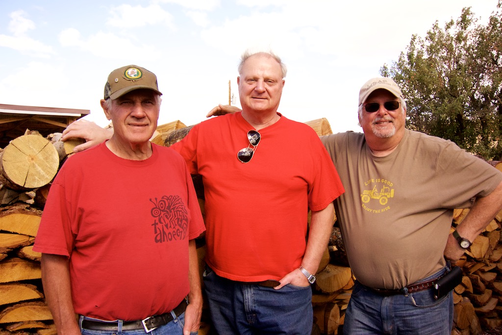
I call this shot "the three amigos." Larry, Bob and I graduated together from Las Lomas High School in Walnut Creek, California back in the early sixties. And haven't seen each other since. Larry and his son run a 2500-acre ranch east of Redmond, near Mitchell, Oregon. It has been in his family for a century or so. Bob and Bonnie took us out there for an afternoon of hamburgers and ATV riding on the ranch. What a blast from the past! By now you are beginning to suspect a theme. At almost every place we went this summer we found someone from Las Lomas. Wasn't an accident.

Paulina Falls: Bob and Bonnie brought us here for a visit to Paulina Lakes.

Marsha and I also visited the Cascade Lakes area of Oregon, east of Bend. We had a nice picnic here. The whole area reminded us a lot of Show Low, with pines and lakes everywhere.

This is the Deschutes River south of Bend. Later it runs through town where these kayakers are enjoying a river training watercourse provided by the city parks people.

From the Bend area we headed home through Sun Valley, Idaho; Logan, Utah; Page, Arizona, and Flagstaff. This is our travel rig seen just south of Page on the Navajo reservation.

After fighting the commuter traffic through Phoenix we decided to stop only 60 miles short of Green Valley, at Picacho Peak State Park, the westernmost battlefield of the civil war. We parked the bus and went outside to watch the sun set over the Saguaro cactus. It was a great end to a great trip!
